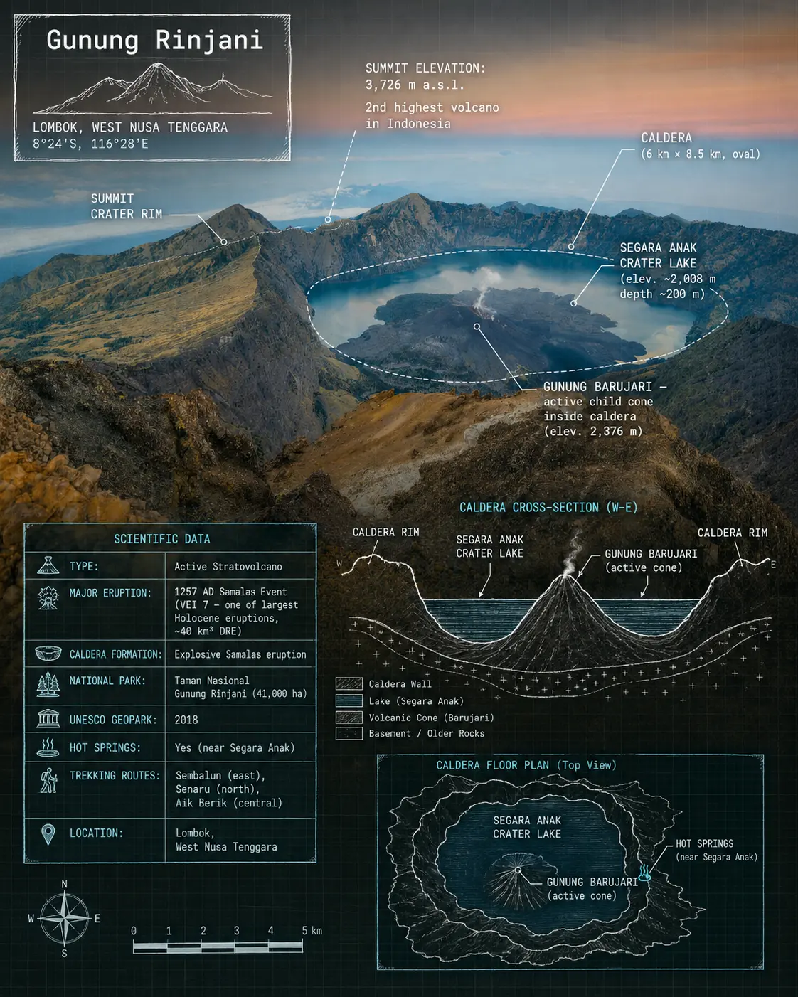
I am uploading a real photograph of Gunung Rinjani, Lombok. Do NOT alter, remove, or add any objects to the photo. Only overlay blueprint-style technical annotations and scientific diagrams on top of the existing image. Keep the original photograph fully intact.

Add the following overlays in a hand-drawn blueprint / scientific field-notes illustration style (white or teal lines on semi-transparent dark layer, monospace annotation font):

- A hand-drawn box in the upper-left corner with the title: Gunung Rinjani
- Elevation annotation on the summit: SUMMIT ELEVATION: 3,726 m a.s.l. | 2nd highest volcano in Indonesia
- Labels pointing to key features visible in or referenced by the photo: SUMMIT CRATER RIM, CALDERA (6 km × 8.5 km, oval), SEGARA ANAK CRATER LAKE (elev. ~2,008 m, depth ~200 m), GUNUNG BARUJARI — active child cone inside caldera (elev. 2,376 m)
- A simplified cross-section diagram showing the caldera structure, Segara Anak lake, and Barujari cone rising from the lake
- Scientific data block: TYPE: Active Stratovolcano | MAJOR ERUPTION: 1257 AD Samalas Event (VEI 7 — one of largest Holocene eruptions, ~40 km³ DRE) | CALDERA FORMATION: Explosive Samalas eruption | NATIONAL PARK: Taman Nasional Gunung Rinjani (41,000 ha) | UNESCO GEOPARK: 2018 | HOT SPRINGS: Yes (near Segara Anak) | TREKKING ROUTES: Sembalun (east), Senaru (north), Aik Berik (central) | LOCATION: Lombok, West Nusa Tenggara
- A small inset floor plan / aerial schematic of the caldera showing the lake, Barujari cone, and hot spring position

Output in 4:5 portrait ratio. No text watermarks, no labels outside annotation style, no watermark.